Not all who wander are lost...

Saturday, October 16, 2010


October 15, 2010 This has absolutely nothing to do with wandering and everything to do with families - ours has been increased by 1. Heather had Felix Orv Barker today at 1:35 pm and as one of the proud grandparents, I have to show off my grandbaby's pictures.


Wednesday, October 13, 2010


Sunday, September 19, 2010 We ended our wonderful trip with friends at Arches National Park.


Now that we've been home for awhile we're ready to head out on our next great adventure. This time, with the "Tough Shed." Stay tuned...

Friday, September 17, 2010 Well, the trip is almost over. As we were heading back to Moab we saw a very strange sight: a HUGE pipe stuck in front of a bridge. You never know what you're going to see in your travels.


As we headed towards Moab I had read in the Boondocking Book that there were dinosaur tracks just off of Highway 191. Since we had been in the sight-seeing mood for two weeks, we decided to stop and check them out.


We got to Moab, picked up our clean bikes and had lunch. We got to the condo before everyone else, so were able to get all our dirty dishes washed, start a load of clothes and to take a shower. It was wonderful! Bob and Susie Bolte, Jim and Jean Bolte, and Amy and Bill Cutting all came by early evening. We had dinner in town and then off to bed for the big bike ride in the morning.

Saturday, September 18, 2010 Steve and I have done this Moab Century ride many times, but this is the first time we didn't do the Big Nasty route. We just were NOT in shape for it. So, a group of us set off about 8:00 to do the "Rollers" route along the river. It was a beautiful morning for a bike ride, but just before starting out Steve looks at the tires on the tandem and said they were looking a little worn; that it may be time to replace them when we get to Salt Lake.

As we were riding along Steve looks up and spots a big horn sheep just off to the side a bit. We all stop and watch him for awhile. He would gracefully bound up the rocks, stop and look at us and pose and then move a little further up. It was an amazing sight.


Back to the bike ride. Steve and I had ridden about 22 miles and were heading down a pretty steep hill when the bike started shaking pretty badly. Steve managed to stop us without any problems happening. When he checked the front tire, it turned out the the tire had started to de-laminate. I guess the tires really were bad! He said we could make it back to the finish line, but shouldn't go fast. So, we turned around and had a nice leisurely ride back. We finished around 12:30, had lunch and a wonderful massage. It turned out to be the perfect distance to ride, later in the day it got really hot and there was a headwind. We chose wisely!
Thursday, September 16, 2010 We awoke on top of a mesa with this being our view. It turned out to be a great spot, with no one around and beautiful vistas. This was definitely a slow morning and we didn't get to the Capitol Reef National Park Visitors' Center until 11:30. We were looking at our options for hiking, trying to decided what to do. One of the ones that looked interesting was the Muley Twist trail, but it turns out it is at thevery southern end of the park and we didn't have time to drive down to it and do the hike.


There was another hike that sounded interesting and close by, 
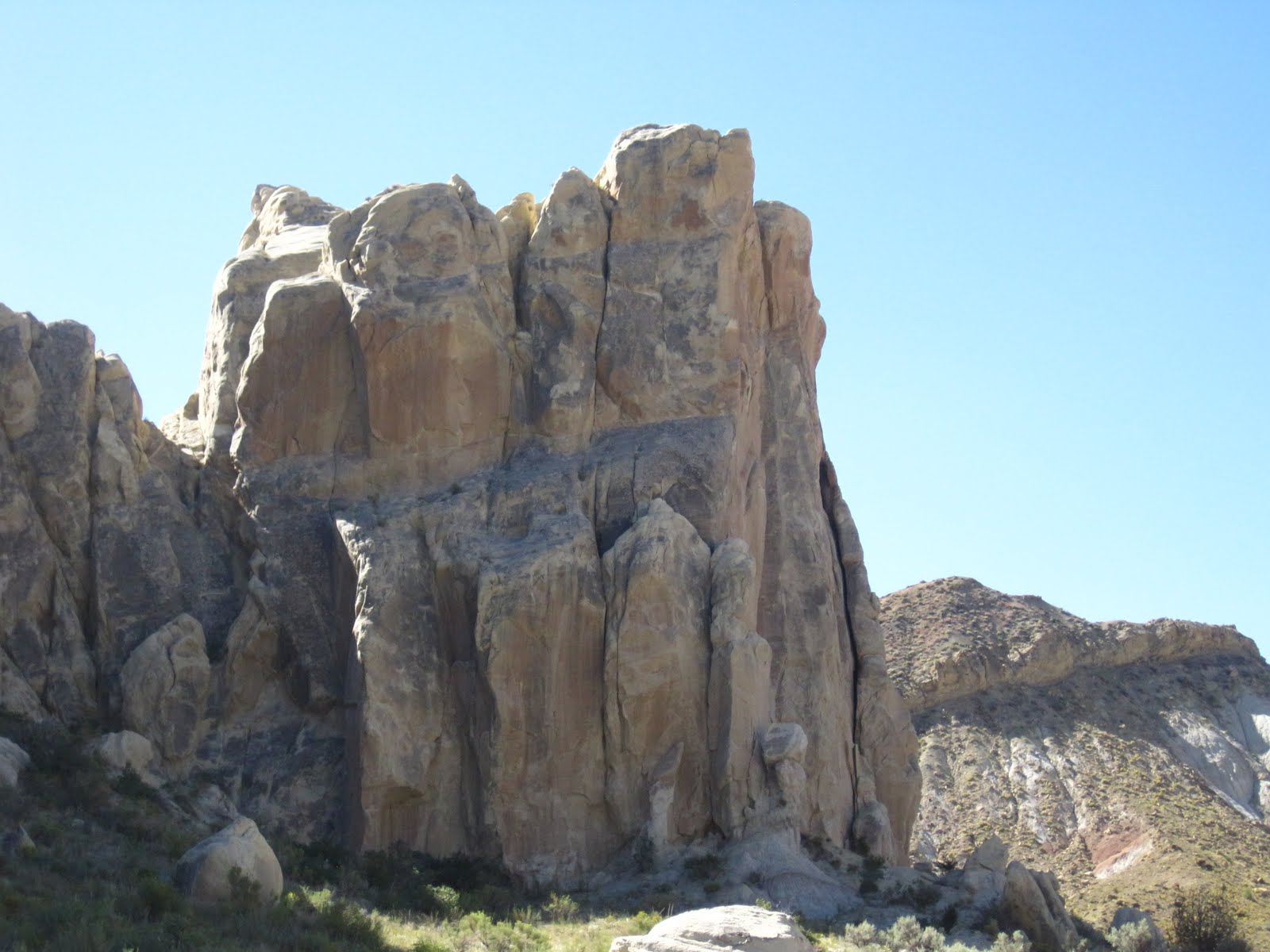
Chimney Rock Trail. It was only a three mile loop, but we thought the views would be nice, which they were. So, at about 12:30 we started our nice and easy hike for the day. As we were on the far side of the loop heading back to the car we passed a trail marker that pointed in one direction to the trail head and the other to Spring Canyon. We felt like we really hadn't hiked very much yet, so we thought we'd check the Canyon out for a little bit. We knew nothing about the trail, but thought it might be interesting.
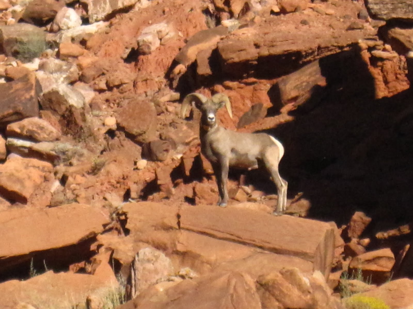
As it turned out, I think this is one of my favorite hikes ever! It was along a dry stream bed and the geology seemed to change around every corner. At the beginning are massive walls on either side, possibly 500 feet above. Then the walls change to hueco (holey) rock, then around the next bend it changes to something else.

After hiking a bit we passed another trail marker. One arrow pointed back the way we came and said the trailhead was 3.5 miles and the other marker pointed down the stream bed and said that Highway 24 was 6.5 miles. We were enjoying the hike and even though it was in the middle of the afternoon, a lot of the stream bed was shaded. Steve said there would be no problem hitchhiking back to the van, even though we had no idea where we would be coming out, so why not go to the end. I was only a little concerned that since we had no idea about this trail, would there be some interesting obstacles along the way to make it difficult to continue.


It was a long hike and we were pretty tired by the end of it, but well worth the effort! It did take 30 minutes or so to get a ride back to the van, but what a great day!


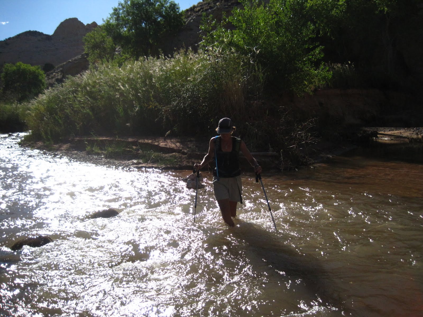
As it turned out, the only difficult part was at the very end when the trail ended at the Freemont River and we had to forge the knee-deep water.


After having a well deserved rest and drink we drove towards Goblin Valley and found a great boondocking place to pop the top. Dinner and bed felt great that night.
Wednesday, September 15, 2010 The night before I had read in my "RV Boondocking In Southern Utah" book about a hike not too far from Kodachrome Basin. We got off to our usual leisurely morning and went in search of Willis Creek. To get there we had to drive on another steep, incredibly thick powdery road. In fact, when we had finished the hike and were driving back to the freeway we passed a plow that was moving the dirt to the side of the road, like a snow plow.


Anyway, this was a great 4 1/2 mile up and back hike. It wound through slot canyons and had a trickle of water going through most of it.


I knew Steve was much better; every time I turned around he was climbing on something.


After Willis Creek we headed to Boulder. Along the way we passed Calf Creek Falls Trail and decided to hike it. It was about 4:30 and it is a 6 mile hike, but we thought we would have enough time to do it before it got dark. It actually was the perfect time to hike; we met only a couple of hikers as we were heading out and no one when we were coming back and the temperature and lighting were perfect. When we got to the falls Steve decided to go skinny dipping but it was way too cold for me!


Heading back Steve spotted the one and only snake we saw on the whole trip.


One of the highlights of the trip was getting to eat at Hell's Backbone Grill. I have wanted to go there for quite some time, but Boulder isn't exactly on the way to anything. After our two hikes of the day, and looking lovely, we decided to see if we could get into the restaurant. We could, and the dinner was wonderful I highly recommend it to anyone traveling in the general area.
After our wonderful dinner, Steve decided we might as well drive up to Capitol Reef that night and see if we could get a camp spot. It was already late, but off we went. Unfortunately (or fortunately) the campgrounds were full and I pulled out my handy Boondocker's guide. They suggested a place down the highway a bit that was just past Capitol Reef boundaries, down a short dirt road. We found the area, or at least we hoped we had; it was pitch dark and we had no idea what the view would be in the morning...
Tuesday, September 14, 2010
This morning we did manage to get up by 8:00, have breakfast and leave to find out our fate in the lottery. (Didn't quite have time for a leisurely cup of coffee at camp.) On the way to the Ranger Station Steve said he had a better plan for us for the next two days even if we did win the lottery. (If our name was called we'd need to figure out a hike today, then do the Wave tomorrow.) We decided to go ahead and find out if we were lucky and possibly give our spot away if we did win. As it turned out there were 59 people vying for the 10 spots. Needless to say, we didn't win.


We decided to head up Cottonwood Canyon Road
a 47-mile dirt road that cuts through the Grand Staircase-Escalante National Monument.
We had traveled on this road once before, probably 12 or 13 years ago. Steve and I and the kids were driving from Phoenix back to Salt Lake and thought it might be fun to drive up this road for a change of pace. It had rained the night before and the sky was very overcast. Tony, who was 11 or 12 read the sign that said "Impassable when wet" and stated that we shouldn't be driving on this road; we might get stuck. Well, we ignored him and went on. When the dirt on this road gets wet, which it was, it turns into "moon mud,"but Steve was driving the Suburban and did do a great job on the traction-less soil. (We did come across a car that was stuck that we helped get out.) We managed to make it all the way, but I was sure Tony would never venture out into the great outdoors; that he would find himself a nice little cubicle to work in. Little did I know that he would eventually become a State Ranger! (You never know about your kids!)


On this Tuesday, however, it was sunny and warm - not a cloud in the sky. If anything, it had been so long since any rain fell that it was tricky driving because of the fine, talcum-like powder the road had turned into. It was an interesting drive, through all different kinds of geological formations.


Midway down this road, in the middle of nowhere and not seeing anyone for miles, we get buzzed by two Air Force jets. It was a bit of a surreal moment.


Eventually we made it to Grosvenor Arch. After we circumnavigated the area we discovered that there are really three arches.


Here's Steve standing in front of the third arch.


After lunch we left the arches and headed to Kodachrome Basin State Park, someplace neither of us had been to before. It is a very nice, small park with free hot showers in the campgrounds! We found a place to camp, popped the top and rested for a couple of hours until it was late afternoon. Then we headed to Shakespeare Arch and saw some interesting pictographs along the way.

Monday, October 11, 2010

Monday, September 12, 2010 We left the North Rim and headed back into Utah. Our goal today was to go to the Paria Ranger Contact Station and find out about the process to get into the lottery to hike the Wave. What we found out was that we had to come back in the morning between 8:30 -9:00 and submit our application. At 9:00 am the rangers would announce what each group's number was and that number would go into a cage. They then spin the cage and draw numbers out until the 10 slots are filled. Those 10 folks then have the privilege of hike the Wave the next day (so for us, if our number was called we could hike on Wednesday). We said we would see them in the morning and left to find a place to camp fairly close by (since we had to be back so early).


There was a dirt road
just down the highway a bit that Steve said looked promising. He thought it was BLM land and it followed Long Canyon, a dry river bed this time of year. We drove up the road about two miles and at a place where the road widened a bit we pulled over, popped the top and boondocked. We got there in the afternoon, so rested for a couple of hours and let the temperature drop a little.


We then explored the canyon, hiking up as far in the canyon as we could until it ended in a cliff. We went back down a bit, scrambled up and walked along the road to see where we head been.


Had our typically wonderful dinner that night, looked at the stars and went to bed.


Sunday, September 12, 2010 Steve and I were trying to figure out which hike we should do today. There was the main Kaibab trail that goes down into the canyon but we heard it was hot, crowded and it's the trail the mules take down (therefore, also know as the "Poopy Trail"). Or we could do the Widforss Trail which was described as a long hike that skirts the edge of the Transept, then cuts through forest to Widforss Point. We chose to do this. For the first 2 1/2 miles we were hiking along the edge with wonderful views of the canyon. Plus there were numbered stops that corresponded to the brochure telling us what we were seeing. (I always like reading and learning about where I am.)


The next 2 1/2 miles was through a forest, with critters and wild flowers.


We ended up at Widforss Point, for a nice rest of nuts and dried fruit. The trail then returns back the same way. Some of the critters we saw along the way was the elusive silver ghost squirrel (that only lives on the North Rim) a woodpecker (actually pecking and throwing bark our way), lizards and horny toads. We only saw 5 couples on the entire 10 mile hike. It was a great hike, but we were tired when we finished. The good news for us was that we were camping at the Grand Canyon campgrounds that had hot showers (you had to pay) and laundry facilities!! That night our bodies and our clothes were clean. (It's the little things in life.)
Our camping spot wasn't exactly level, but after the hike, cleaning up, dinner and going to the Ranger's talk about cougars we slept very soundly.
Saturday, September 11, 2010 While we were having dinner last night, Ila told us we had to go to Antelope Canyon. He said that it was a slot canyon, on Navajo land, that is well known for the beautiful pictures taken in it. He said to be sure and be there between 11 and 1, when the light is the best. We were heading to the North Rim of the Grand Canyon, and when we looked at the map, realized we'd be going right by the area. So, this morning, we got up bright and early for us (8:00) had breakfast and left the Navajo National Park by 9:00. There are at least three different areas that you can go to in the canyon; we wanted to go to the "Corkscrew". This was actually the canyon that 12 people had died in a flash flood several years ago. But the skies were clear and we eventually got to the right spot and we were there at the right time.


Oh, my gosh, it is amazing.


From here we headed to the Grand Canyon. I had never been to the North Rim, and it is beautiful. I love having the overlooks and to be among pine trees. When we first got to the Rim we took a small hike to Angel's Point. As we were walking back a woman asks, "Jane?" It turns out it was Diane Farr from Utah. She was there with her husband and 5 other couples to celebrate her birthday. I bring this up just to remind you that it is a small world, and you never know when or where you'll run into someone you know!

Tonight, we actually stayed in a hotel, The Grand Canyon Lodge. Camping in the Beast has been great, but there isn't a shower and everywhere we camped, there wasn't a shower. One can only do so much with sponge baths, and the worst for wear was definitely my hair. I was thrilled to actually wash it!

Around 6:00 pm we walked down to the main lodge to see the sunset. And it was lovely.


It was nice to sleep in a bed, but I missed the Beast.

Friday, September 10: After driving the north rim of Canyon de Chelly we decided to spend the night at Navajo National Monument. This is a small, but beautiful park. We found a campsite with a overlooking the valley.


There were a couple of short hikes from the visitors center. One hike went down a small canyon and when we looked up to the cliff edge, we realized the buzzards were watching...


While we were down in this canyon, a young man came bounding along. As we talked with him we learned that he was from Italy, traveling the three Americas for a year on a Vespa! He had already traveled for three months, starting out in New York, headed to Alaska, had been to the Burning Man in Nevada, and eventually would up at the tip of South America. All on a Vespa! I thought we were roughing it in the Beast.


That night we had Ilario Lavarra (what a great name) over for dinner and wine...


and had the prettiest sunset of our trip.